Weather Alert in Michigan
Air Quality Alert issued July 15 at 1:26PM EDT by NWS Northern Indiana
AREAS AFFECTED: Cass; Northern Berrien; Southern Berrien
DESCRIPTION: The Michigan Department of Environment, Great Lakes, and Energy (EGLE) has declared an Air Quality Advisory for Tuesday July 15 and Wednesday July 16, for elevated levels of ozone and fine particulate (PM2.5) in parts of southwest Michigan. Pollutants within those areas are expected to be in the Unhealthy for Sensitive Groups (USG, Orange AQI) range. The Air Quality Advisory is in effect for the following counties in southwest Michigan... Berrien and Cass Wildfire smoke may trigger elevated particulates and ozone levels. It is recommended that, when possible, you stay indoors and keep time outdoors short and avoid strenuous activities, especially those with respiratory diseases such as asthma. Recommendations to reduce pollution and potential health effects: PM 2.5: * Reduce or eliminate outdoor burning, and the use of residential wood burning devices; * Keep windows closed overnight to prevent smoke from getting indoors, and, if possible, run central air conditioning with MERV- 13 or higher rated filters. Ozone: * Using gas-powered lawn equipment; * Driving less or delaying and/or combining errands; * Refueling less or topping off when refueling. For up-to-date air quality data for Michigan visit the MiAir site: https://air-egle.hub.arcgis.com/ For up-to-date air quality data nationally visit EPA's Air Now site: https://www.airnow.gov/ For further health information, please see MDHHS's Wildfire Smoke and You Health site: https://www.michigan.gov/mdhhs/safety-injury-prev/environmental- health/your-health-and-wildfire-smoke
INSTRUCTION: N/A
Want more detail? Get the Complete 7 Day and Night Detailed Forecast!
Current U.S. National Radar--Current
The Current National Weather Radar is shown below with a UTC Time (subtract 5 hours from UTC to get Eastern Time).

National Weather Forecast--Current
The Current National Weather Forecast and National Weather Map are shown below.

National Weather Forecast for Tomorrow
Tomorrow National Weather Forecast and Tomorrow National Weather Map are show below.

North America Water Vapor (Moisture)
This map shows recent moisture content over North America. Bright and colored areas show high moisture (ie, clouds); brown indicates very little moisture present; black indicates no moisture.

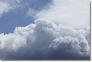
Weather Topic: What are Nimbostratus Clouds?
Home - Education - Cloud Types - Nimbostratus Clouds
 Next Topic: Precipitation
A nimbostratus cloud is similar to a stratus cloud in its formless,
smooth appearance. However, a nimbostratus cloud is darker than a stratus cloud,
because it is thicker.
Unlike a stratus cloud, a nimbostratus cloud typically brings with it the threat
of moderate to heavy precipitation. In some cases, the precipitation may evaporate
before reaching the ground, a phenomenon known as virga.
Next Topic: Precipitation
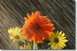
Weather Topic: What is Rain?
Home - Education - Precipitation - Rain
 Next Topic: Shelf Clouds
Precipitation in the form of water droplets is called rain.
Rain generally has a tendency to fall with less intensity over a greater period
of time, and when rainfall is more severe it is usually less sustained.
Rain is the most common form of precipitation and happens with greater frequency
depending on the season and regional influences. Cities have been shown to have
an observable effect on rainfall, due to an effect called the urban heat island.
Compared to upwind, monthly rainfall between twenty and forty miles downwind of
cities is 30% greater.
Next Topic: Shelf Clouds
Current conditions powered by WeatherAPI.com


