Weather Alert in California
Wind Advisory issued February 19 at 11:02PM PST until February 22 at 10:00AM PST by NWS Eureka CA
AREAS AFFECTED: Del Norte Interior; Northern Humboldt Interior; Southern Humboldt Interior
DESCRIPTION: * WHAT...Very cold wind chills as low as 15 expected. For the Wind Advisory, southeast winds 20 to 30 mph with gusts up to 55 mph expected. * WHERE...Humboldt Interior, and Del Norte Interior. * WHEN...For the Cold Weather Advisory, until 9 AM PST Friday. For the Wind Advisory, from 10 PM Friday to 10 AM PST Sunday. * IMPACTS...Wind gusts will be particularly strong along windward ridges and exposed coastal headlands. Wind chill values can lead to hypothermia with prolonged exposure.
INSTRUCTION: Winds this strong can make driving difficult, especially for high profile vehicles. Use extra caution. Secure outdoor objects. Use caution while traveling outside. Wear appropriate clothing, a hat, and gloves.
Want more detail? Get the Complete 7 Day and Night Detailed Forecast!
Current U.S. National Radar--Current
The Current National Weather Radar is shown below with a UTC Time (subtract 5 hours from UTC to get Eastern Time).

National Weather Forecast--Current
The Current National Weather Forecast and National Weather Map are shown below.

National Weather Forecast for Tomorrow
Tomorrow National Weather Forecast and Tomorrow National Weather Map are show below.

North America Water Vapor (Moisture)
This map shows recent moisture content over North America. Bright and colored areas show high moisture (ie, clouds); brown indicates very little moisture present; black indicates no moisture.

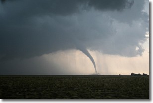
Weather Topic: What are Wall Clouds?
Home - Education - Cloud Types - Wall Clouds
 Next Topic: Altocumulus Clouds
A wall cloud forms underneath the base of a cumulonimbus cloud,
and can be a hotbed for deadly tornadoes.
Wall clouds are formed by air flowing into the cumulonimbus clouds, which can
result in the wall cloud descending from the base of the cumulonimbus cloud, or
rising fractus clouds which join to the base of the storm cloud as the wall cloud
takes shape.
Wall clouds can be very large, and in the Northern Hemisphere they generally
form at the southern edge of cumulonimbus clouds.
Next Topic: Altocumulus Clouds
Weather Topic: What are Altostratus Clouds?
Home - Education - Cloud Types - Altostratus Clouds
 Next Topic: Cirrocumulus Clouds
Altostratus clouds form at mid to high-level altitudes
(between 2 and 7 km) and are created by a warm, stable air mass which causes
water vapor
to condense as it rise through the atmosphere. Usually altostratus clouds are
featureless sheets characterized by a uniform color.
In some cases, wind punching through the cloud formation may give it a waved
appearance, called altostratus undulatus. Altostratus clouds
are commonly seen with other cloud formations accompanying them.
Next Topic: Cirrocumulus Clouds
Current conditions powered by WeatherAPI.com


