Weather Alert in Texas
Flood Advisory issued July 29 at 12:04AM MDT until July 29 at 3:15AM MDT by NWS El Paso Tx/Santa Teresa NM
AREAS AFFECTED: Hudspeth, TX
DESCRIPTION: * WHAT...Arroyo and small stream flooding caused by excessive rainfall is expected. * WHERE...Southern Hudspeth County in far West Texas. * WHEN...Until 315 AM MDT. * IMPACTS...Rises in small streams and normally dry arroyos. Dangerous flows over low-water crossings. Water over roadways. * ADDITIONAL DETAILS... - At 1204 AM MDT, Heavy rain has redeveloped over southern Hudspeth County, particulary south of I-10 between Esperanza and Sierra Blanca. Low water crossings, many of which have likely already seen flows earlier this evening, will become inundated in the area. - Some locations that may experience flooding include... Numerous low water crossings along FM-192, FM-34, and Quitman Canyon Road. Red Light Draw. Sierra Blanca, Indian Hot Springs, Fort Quitman, Esperanza and Quitman Canyon. - http://www.weather.gov/safety/flood
INSTRUCTION: Turn around, don't drown when encountering flooded roads. Most flood deaths occur in vehicles. Be especially cautious at night when it is harder to recognize the dangers of flooding.
Want more detail? Get the Complete 7 Day and Night Detailed Forecast!
Current U.S. National Radar--Current
The Current National Weather Radar is shown below with a UTC Time (subtract 5 hours from UTC to get Eastern Time).

National Weather Forecast--Current
The Current National Weather Forecast and National Weather Map are shown below.

National Weather Forecast for Tomorrow
Tomorrow National Weather Forecast and Tomorrow National Weather Map are show below.

North America Water Vapor (Moisture)
This map shows recent moisture content over North America. Bright and colored areas show high moisture (ie, clouds); brown indicates very little moisture present; black indicates no moisture.

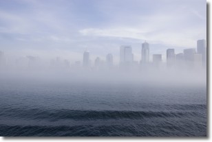
Weather Topic: What is Fog?
Home - Education - Cloud Types - Fog
 Next Topic: Fractus Clouds
Fog is technically a type of stratus cloud, which lies along the
ground and obscures visibility.
It is usually created when humidity in the air condenses into tiny water droplets.
Because of this, some places are more prone to foggy weather, such as regions
close to a body of water.
Fog is similar to mist; both are the appearance of water droplets suspended in
the air, but fog is the term applied to the condition when visibility is less than 1 km.
Next Topic: Fractus Clouds
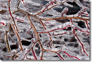
Weather Topic: What is Freezing Rain?
Home - Education - Precipitation - Freezing Rain
 Next Topic: Graupel
Freezing rain is a condition where precipitation which has fallen in the form of
water droplets reaches temperatures which are below freezing and freezes upon
coming into contact
with surface objects. The result of this precipitation is a glaze of ice which
can be damaging to plants and man-made structures. A severe onset of freezing
rain which results in a very thick glaze of ice is known as an ice storm.
Next Topic: Graupel
Current conditions powered by WeatherAPI.com


