Weather Alert in New York
Air Quality Alert issued April 23 at 1:28PM EDT by NWS Upton NY
AREAS AFFECTED: Rockland; Northern Westchester; Southern Westchester; New York (Manhattan); Bronx; Richmond (Staten Is.); Kings (Brooklyn); Northwest Suffolk; Northeast Suffolk; Southwest Suffolk; Southeast Suffolk; Northern Queens; Northern Nassau; Southern Queens; Southern Nassau
DESCRIPTION: The New York State Department of Environmental Conservation has issued an Air Quality Health Advisory for the following counties: New York, Bronx, Kings, Queens, Richmond, Nassau, Suffolk, Westchester, Rockland. from midnight tonight to midnight EDT Thursday night. Air quality levels in outdoor air are predicted to be greater than an Air Quality Index value of 100 for the pollutant of Fine Particulates. The Air Quality Index, or AQI, was created as an easy way to correlate levels of different pollutants to one scale. The higher the AQI value, the greater the health concern. When pollution levels are elevated, the New York State Department of Health recommends that individuals consider limiting strenuous outdoor physical activity to reduce the risk of adverse health effects. People who may be especially sensitive to the effects of elevated levels of pollutants include the very young, and those with preexisting respiratory problems such as asthma or heart disease. Those with symptoms should consider consulting their personal physician. A toll free air quality hotline has been established so New York residents can stay informed on the air quality situation. The toll free number is 1 800 5 3 5, 1 3 4 5.
INSTRUCTION: N/A
Want more detail? Get the Complete 7 Day and Night Detailed Forecast!
Current U.S. National Radar--Current
The Current National Weather Radar is shown below with a UTC Time (subtract 5 hours from UTC to get Eastern Time).

National Weather Forecast--Current
The Current National Weather Forecast and National Weather Map are shown below.

National Weather Forecast for Tomorrow
Tomorrow National Weather Forecast and Tomorrow National Weather Map are show below.

North America Water Vapor (Moisture)
This map shows recent moisture content over North America. Bright and colored areas show high moisture (ie, clouds); brown indicates very little moisture present; black indicates no moisture.

Weather Topic: What are Cumulus Clouds?
Home - Education - Cloud Types - Cumulus Clouds
 Next Topic: Drizzle
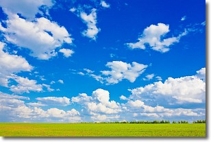
Cumulus clouds are fluffy and textured with rounded tops, and
may have flat bottoms. The border of a cumulus cloud
is clearly defined, and can have the appearance of cotton or cauliflower.
Cumulus clouds form at low altitudes (rarely above 2 km) but can grow very tall,
becoming cumulus congestus and possibly the even taller cumulonimbus clouds.
When cumulus clouds become taller, they have a greater chance of producing precipitation.
Next Topic: Drizzle
Weather Topic: What is Evaporation?
Home - Education - Precipitation - Evaporation
 Next Topic: Fog
Evaporation is the process which returns water from the earth
back to the atmosphere, and is another crucial process in the water cycle.
Evaporation is the transformation of liquid into gas, and it happens because
molecules are excited by the application of energy and turn into vapor.
In order for water to evaporate it has to be on the surface of a body of water.
Next Topic: Fog
Current conditions powered by WeatherAPI.com


