Weather Alert in Wisconsin
Winter Weather Advisory issued April 3 at 2:38AM CDT until April 4 at 7:00AM CDT by NWS La Crosse WI
AREAS AFFECTED: Taylor; Clark
DESCRIPTION: ...FREEZING RAIN IMPACTING NORTH CENTRAL WISCONSIN THIS EVENING INTO THE OVERNIGHT... .Freezing rain develops this evening and continues through the overnight for north central Wisconsin. This impacts Taylor County and northeast Clark County. The greatest ice accumulations are in eastern Taylor County. There is a tight gradient in ice accumulations owing to where the freezing line sets up, so additional shifts in the southward extent of the ice may be needed later in the day. * WHAT...Freezing rain expected. Total ice accumulations ranging from a glaze to a tenth of an inch of ice for northeast Clark and western and central Taylor County. Higher amounts between a tenth to three tenths for eastern Taylor County. * WHERE...Clark and Taylor Counties. * WHEN...From 9 PM this evening to 7 AM CDT Saturday. * IMPACTS...Power outages and tree damage are possible due to the ice. Slippery roads are possible.
INSTRUCTION: Slow down and use caution while traveling. Prepare for possible power outages. Visit 511wi.gov for road conditions.
Want more detail? Get the Complete 7 Day and Night Detailed Forecast!
Current U.S. National Radar--Current
The Current National Weather Radar is shown below with a UTC Time (subtract 5 hours from UTC to get Eastern Time).

National Weather Forecast--Current
The Current National Weather Forecast and National Weather Map are shown below.

National Weather Forecast for Tomorrow
Tomorrow National Weather Forecast and Tomorrow National Weather Map are show below.

North America Water Vapor (Moisture)
This map shows recent moisture content over North America. Bright and colored areas show high moisture (ie, clouds); brown indicates very little moisture present; black indicates no moisture.

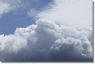
Weather Topic: What are Nimbostratus Clouds?
Home - Education - Cloud Types - Nimbostratus Clouds
 Next Topic: Precipitation
A nimbostratus cloud is similar to a stratus cloud in its formless,
smooth appearance. However, a nimbostratus cloud is darker than a stratus cloud,
because it is thicker.
Unlike a stratus cloud, a nimbostratus cloud typically brings with it the threat
of moderate to heavy precipitation. In some cases, the precipitation may evaporate
before reaching the ground, a phenomenon known as virga.
Next Topic: Precipitation
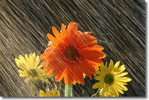
Weather Topic: What is Rain?
Home - Education - Precipitation - Rain
 Next Topic: Shelf Clouds
Precipitation in the form of water droplets is called rain.
Rain generally has a tendency to fall with less intensity over a greater period
of time, and when rainfall is more severe it is usually less sustained.
Rain is the most common form of precipitation and happens with greater frequency
depending on the season and regional influences. Cities have been shown to have
an observable effect on rainfall, due to an effect called the urban heat island.
Compared to upwind, monthly rainfall between twenty and forty miles downwind of
cities is 30% greater.
Next Topic: Shelf Clouds
Current conditions powered by WeatherAPI.com


