Weather Alert in California
Heat Advisory issued May 29 at 12:17PM PDT until May 31 at 11:00PM PDT by NWS Sacramento CA
AREAS AFFECTED: Shasta Lake Area / Northern Shasta County; Northern Sacramento Valley; Central Sacramento Valley; Southern Sacramento Valley; Carquinez Strait and Delta; Northern San Joaquin Valley; Mountains Southwestern Shasta County to Western Colusa County; Northeast Foothills/Sacramento Valley; Motherlode
DESCRIPTION: * WHAT...Dangerously hot conditions with temperatures 99 to 107 and widespread Major HeatRisk expected. Limited overnight relief with low temperatures in the mid 60s to mid 70s. * WHERE...Carquinez Strait and Delta, Central Sacramento Valley, Motherlode, Mountains Southwestern Shasta County to Western Colusa County, Northeast Foothills/Sacramento Valley, Northern Sacramento Valley, Northern San Joaquin Valley, Shasta Lake Area / Northern Shasta County, and Southern Sacramento Valley. * WHEN...From 11 AM Friday to 11 PM PDT Saturday. * IMPACTS...Heat related illnesses increase significantly during extreme heat events, particularly for those working or participating in outdoor activities. * ADDITIONAL DETAILS...Area waterways continue to run cold and fast, creating dangerous conditions for those seeking relief in rivers and lakes.
INSTRUCTION: Drink plenty of fluids, stay in an air-conditioned room, stay out of the sun, and check up on relatives and neighbors. Do not leave young children and pets in unattended vehicles. Car interiors will reach lethal temperatures in a matter of minutes.
Want more detail? Get the Complete 7 Day and Night Detailed Forecast!
Current U.S. National Radar--Current
The Current National Weather Radar is shown below with a UTC Time (subtract 5 hours from UTC to get Eastern Time).

National Weather Forecast--Current
The Current National Weather Forecast and National Weather Map are shown below.

National Weather Forecast for Tomorrow
Tomorrow National Weather Forecast and Tomorrow National Weather Map are show below.

North America Water Vapor (Moisture)
This map shows recent moisture content over North America. Bright and colored areas show high moisture (ie, clouds); brown indicates very little moisture present; black indicates no moisture.

Weather Topic: What is Drizzle?
Home - Education - Precipitation - Drizzle
 Next Topic: Evaporation
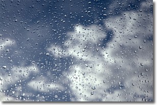
Drizzle is precipitation in the form of water droplets which are
smaller than raindrops.
Drizzle is characterized by fine, gently falling droplets and typically does not
impact human habitation in a negative way. The exception to this is freezing drizzle,
a condition where drizzle freezes immediately upon reaching earth's surface.
Freezing drizzle is still less dangerous than freezing rain, but can
potentially result in hazardous road conditions.
Next Topic: Evaporation
Weather Topic: What is Fog?
Home - Education - Cloud Types - Fog
 Next Topic: Fractus Clouds
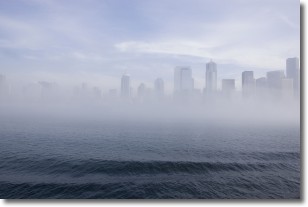
Fog is technically a type of stratus cloud, which lies along the
ground and obscures visibility.
It is usually created when humidity in the air condenses into tiny water droplets.
Because of this, some places are more prone to foggy weather, such as regions
close to a body of water.
Fog is similar to mist; both are the appearance of water droplets suspended in
the air, but fog is the term applied to the condition when visibility is less than 1 km.
Next Topic: Fractus Clouds
Current conditions powered by WeatherAPI.com


