Weather Alert in Montana
Special Weather Statement issued February 20 at 6:39PM MST by NWS Billings MT
AREAS AFFECTED: Northern Stillwater; Northern Carbon; Northeastern Yellowstone; Southwestern Yellowstone
DESCRIPTION: At 639 PM MST, Doppler radar was tracking snow showers along a line from 8 miles southeast of Ryegate to 9 miles north of Absarokee moving east at 25 mph. Locations impacted include... Billings, Columbus, Laurel, Joliet, Fromberg, Lockwood, Shepherd, Huntley, Worden, Ballantine, Broadview, Acton, Molt, Park City, and Rockvale. Visibility under 2 miles and a quick 0.5" of snow should be expected.
INSTRUCTION: Use extra caution if you must travel into or through this area of snow. Rapid changes in visibility and potentially slick roads may lead to accidents. Consider delaying travel until the snow passes your location. Conditions can deteriorate rapidly in winter weather situations. Be prepared for snow or ice covered roads. Slow down and allow extra time when traveling.
Want more detail? Get the Complete 7 Day and Night Detailed Forecast!
Current U.S. National Radar--Current
The Current National Weather Radar is shown below with a UTC Time (subtract 5 hours from UTC to get Eastern Time).

National Weather Forecast--Current
The Current National Weather Forecast and National Weather Map are shown below.

National Weather Forecast for Tomorrow
Tomorrow National Weather Forecast and Tomorrow National Weather Map are show below.

North America Water Vapor (Moisture)
This map shows recent moisture content over North America. Bright and colored areas show high moisture (ie, clouds); brown indicates very little moisture present; black indicates no moisture.

Weather Topic: What are Stratus Clouds?
Home - Education - Cloud Types - Stratus Clouds
 Next Topic: Wall Clouds
Stratus clouds are similar to altostratus clouds, but form at a
lower altitude and are identified by their fog-like appearance, lacking the
distinguishing features of most clouds.
Stratus clouds are wider than most clouds, and their base has a smooth, uniform
look which is lighter in color than a nimbostratus cloud.
The presence of a stratus cloud indicates the possibility of minor precipitation,
such as drizzle, but heavier precipitation does not typically arrive in the form
of a stratus cloud.
Next Topic: Wall Clouds
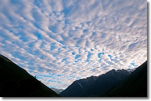
Weather Topic: What are Altocumulus Clouds?
Home - Education - Cloud Types - Altocumulus Clouds
 Next Topic: Altostratus Clouds
Similar to cirrocumulus clouds, altocumulus clouds are
characterized by cloud patches. They are distinguished by larger cloudlets
than cirrocumulus clouds but are still smaller than stratocumulus clouds.
Altocumulus clouds most commonly form in middle altitudes (between 2 and 5 km)
and may resemble, at times, the shape of a flying saucer.
These uncommon formations, called altocumulus lenticularis, are created by uplift
in the atmosphere and are most often seen in close proximity to mountains.
Next Topic: Altostratus Clouds
Current conditions powered by WeatherAPI.com


