Weather Alerts for California
1. Flood Advisory for: San Bernardino, CA
2. Flood Advisory for: San Diego, CA
3. Flood Watch for: Death Valley National Park; Western Mojave Desert; Eastern Mojave Desert, Including the Mojave National Preserve; Morongo Basin; Cadiz Basin
4. Flood Watch for: Kaiser to Rodgers Ridge; Kings Canyon NP; Grant Grove Area; Sequoia NP; South End of the Upper Sierra; Kern River Valley; Piute Walker Basin; Tehachapi; Indian Wells Valley; Mojave Desert Slopes; Mojave Desert
5. Flood Watch for: Western San Gabriel Mountains and Highway 14 Corridor; Eastern San Gabriel Mountains; Western Antelope Valley Foothills; Eastern Antelope Valley Foothills; Antelope Valley
6. Heat Advisory for: Cuyama Valley; San Luis Obispo County Interior Valleys; San Luis Obispo County Mountains; Santa Barbara County Interior Mountains
7. Heat Advisory for: Northern Ventura County Mountains
8. Heat Advisory for: San Bernardino and Riverside County Valleys-The Inland Empire; San Diego County Inland Valleys; Santa Ana Mountains and Foothills; Orange County Inland
9. Heat Advisory for: Santa Clarita Valley; Lake Casitas; Ojai Valley; Central Ventura County Valleys; Los Angeles County Inland Coast including Downtown Los Angeles; Western Santa Monica Mountains Recreational Area; Eastern Santa Monica Mountains Recreational Area; Calabasas and Agoura Hills; Western San Fernando Valley; Eastern San Fernando Valley; Southeastern Ventura County Valleys; Santa Susana Mountains; Southern Ventura County Mountains; Interstate 5 Corridor; Western San Gabriel Mountains and Highway 14 Corridor; Los Angeles County San Gabriel Valley
10. Heat Advisory for: Santa Ynez Mountains Eastern Range
11. Heat Advisory for: Ventura County Inland Coast
12. Red Flag Warning for: Lower Middle Klamath; Trinity
13. Red Flag Warning for: Siskiyou County from the Cascade Mountains East and South to Mt Shasta; Modoc County Except for the Surprise Valley; Umpqua National Forest; Southern Oregon Cascades; Klamath Basin and the Fremont-Winema National Forest; South Central Oregon Desert including the BLM Land in Eastern Lake and Western Harney Counties
14. Red Flag Warning for: Surprise Valley California; Eastern Lassen County; Northern Washoe County
15. Red Flag Warning for: Western Klamath National Forest; Central Siskiyou County Including Shasta Valley; Siskiyou Mountains
16. Special Weather Statement for: Merced - Madera - Mendota; Planada - Le Grand - Snelling; Fresno-Clovis; Mariposa Madera Foothills
Want more detail? Get the Complete 7 Day and Night Detailed Forecast!
Current U.S. National Radar--Current
The Current National Weather Radar is shown below with a UTC Time (subtract 5 hours from UTC to get Eastern Time).

National Weather Forecast--Current
The Current National Weather Forecast and National Weather Map are shown below.

National Weather Forecast for Tomorrow
Tomorrow National Weather Forecast and Tomorrow National Weather Map are show below.

North America Water Vapor (Moisture)
This map shows recent moisture content over North America. Bright and colored areas show high moisture (ie, clouds); brown indicates very little moisture present; black indicates no moisture.

Weather Topic: What are Stratus Clouds?
Home - Education - Cloud Types - Stratus Clouds
 Next Topic: Wall Clouds
Stratus clouds are similar to altostratus clouds, but form at a
lower altitude and are identified by their fog-like appearance, lacking the
distinguishing features of most clouds.
Stratus clouds are wider than most clouds, and their base has a smooth, uniform
look which is lighter in color than a nimbostratus cloud.
The presence of a stratus cloud indicates the possibility of minor precipitation,
such as drizzle, but heavier precipitation does not typically arrive in the form
of a stratus cloud.
Next Topic: Wall Clouds
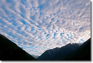
Weather Topic: What are Altocumulus Clouds?
Home - Education - Cloud Types - Altocumulus Clouds
 Next Topic: Altostratus Clouds
Similar to cirrocumulus clouds, altocumulus clouds are
characterized by cloud patches. They are distinguished by larger cloudlets
than cirrocumulus clouds but are still smaller than stratocumulus clouds.
Altocumulus clouds most commonly form in middle altitudes (between 2 and 5 km)
and may resemble, at times, the shape of a flying saucer.
These uncommon formations, called altocumulus lenticularis, are created by uplift
in the atmosphere and are most often seen in close proximity to mountains.
Next Topic: Altostratus Clouds
Current conditions powered by WeatherAPI.com


