Weather Alerts for Montana
1. High Wind Warning for: Absaroka/Beartooth Mountains
2. High Wind Warning for: Big Belt, Bridger and Castle Mountains; Meagher County Valleys; Elkhorn and Boulder Mountains; Canyon Ferry Area; Missouri Headwaters
3. High Wind Warning for: Cascade County below 5000ft
4. High Wind Warning for: Crazy Mountains
5. High Wind Warning for: East Glacier Park Region; Northern High Plains; Eastern Glacier, Western Toole, and Central Pondera; Southern Rocky Mountain Front; Southern High Plains
6. High Wind Warning for: Eastern Toole and Liberty; Hill County; Northern Blaine County; Eastern Pondera and Eastern Teton; Western and Central Chouteau County; Bears Paw Mountains and Southern Blaine; Fergus County below 4500ft; Upper Blackfoot and MacDonald Pass; Gates of the Mountains; Little Belt and Highwood Mountains; Snowy and Judith Mountains; Helena Valley
7. High Wind Warning for: Judith Basin County and Judith Gap
8. High Wind Warning for: Judith Gap; Northern Sweet Grass; Melville Foothills; Southern Wheatland
9. High Wind Warning for: Livingston Area; Beartooth Foothills
10. High Wind Warning for: Musselshell; Northern Stillwater; Golden Valley
11. High Wind Warning for: Northeastern Yellowstone; Southwestern Yellowstone
12. High Wind Warning for: Southwest Phillips
13. High Wind Warning for: West Glacier Region
14. Wind Advisory for: Kootenai/Cabinet Region; Flathead/Mission Valleys
15. Wind Advisory for: Lower Clark Fork Region; Missoula/Bitterroot Valleys; Bitterroot/Sapphire Mountains; Butte/Blackfoot Region; Potomac/Seeley Lake Region
16. Winter Weather Advisory for: Southwest Phillips
Want more detail? Get the Complete 7 Day and Night Detailed Forecast!
Current U.S. National Radar--Current
The Current National Weather Radar is shown below with a UTC Time (subtract 5 hours from UTC to get Eastern Time).

National Weather Forecast--Current
The Current National Weather Forecast and National Weather Map are shown below.

National Weather Forecast for Tomorrow
Tomorrow National Weather Forecast and Tomorrow National Weather Map are show below.

North America Water Vapor (Moisture)
This map shows recent moisture content over North America. Bright and colored areas show high moisture (ie, clouds); brown indicates very little moisture present; black indicates no moisture.

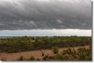
Weather Topic: What are Shelf Clouds?
Home - Education - Cloud Types - Shelf Clouds
 Next Topic: Sleet
A shelf cloud is similar to a wall cloud, but forms at the front
of a storm cloud, instead of at the rear, where wall clouds form.
A shelf cloud is caused by a series of events set into motion by the advancing
storm; first, cool air settles along the ground where precipitation has just fallen.
As the cool air is brought in, the warmer air is displaced, and rises above it,
because it is less dense. When the warmer air reaches the bottom of the storm cloud,
it begins to cool again, and the resulting condensation is a visible shelf cloud.
Next Topic: Sleet
Weather Topic: What is Snow?
Home - Education - Precipitation - Snow
 Next Topic: Stratocumulus Clouds
Snow is precipitation taking the form of ice crystals. Each ice crystal, or snowflake,
has unique characteristics, but all of them grow in a hexagonal structure.
Snowfall can last for sustained periods of time and result in significant buildup
of snow on the ground.
On the earth's surface, snow starts out light and powdery, but as it begins to melt
it tends to become more granular, producing small bits of ice which have the consistency of
sand. After several cycles of melting and freezing, snow can become very dense
and ice-like, commonly known as snow pack.
Next Topic: Stratocumulus Clouds
Current conditions powered by WeatherAPI.com


