Weather Alerts for Montana
High Wind Watch Winter Storm Watch
1. Fire Weather Watch for: Dawson/McCone/Prairie/Richland/Wibaux Counties
2. Fire Weather Watch for: Fort Peck Reservation and Daniels/Roosevelt/Sheridan Counties; Northern Valley and Northern Phillips Counties; The Little Rockies; The Lower Missouri River Breaks including the Charles M Russell National Wildlife Refuge; Southern Petroleum and Southern Garfield Counties
3. High Wind Warning for: Madison River Valley
4. High Wind Watch for: Central and Southeast Phillips; Central and Southern Valley; Petroleum; Garfield; Northern Phillips; Southwest Phillips; Northern Valley
5. High Wind Watch for: Daniels; Sheridan; Western Roosevelt; McCone; Richland; Dawson; Prairie; Wibaux; Eastern Roosevelt
6. High Wind Watch for: Eastern Toole and Liberty; Hill County; Northern Blaine County; Western and Central Chouteau County; Bears Paw Mountains and Southern Blaine; Fergus County below 4500ft
7. Winter Storm Watch for: Absaroka/Beartooth Mountains
8. Winter Storm Watch for: Gallatin Valley
9. Winter Storm Watch for: Judith Basin County and Judith Gap; Fergus County below 4500ft; Snowy and Judith Mountains
10. Winter Storm Watch for: Little Belt and Highwood Mountains; Big Belt, Bridger and Castle Mountains; Gallatin and Madison County Mountains and Centennial Mountains
11. Winter Weather Advisory for: Bears Paw Mountains and Southern Blaine
12. Winter Weather Advisory for: Bitterroot/Sapphire Mountains
13. Winter Weather Advisory for: Butte/Blackfoot Region
14. Winter Weather Advisory for: East Glacier Park Region; Northern High Plains
15. Winter Weather Advisory for: Potomac/Seeley Lake Region
16. Winter Weather Advisory for: Southern Rocky Mountain Front; Upper Blackfoot and MacDonald Pass; Gates of the Mountains; Elkhorn and Boulder Mountains; Northwest Beaverhead County; Ruby Mountains and Southern Beaverhead Mountains
17. Winter Weather Advisory for: West Glacier Region
Want more detail? Get the Complete 7 Day and Night Detailed Forecast!
Current U.S. National Radar--Current
The Current National Weather Radar is shown below with a UTC Time (subtract 5 hours from UTC to get Eastern Time).

National Weather Forecast--Current
The Current National Weather Forecast and National Weather Map are shown below.

National Weather Forecast for Tomorrow
Tomorrow National Weather Forecast and Tomorrow National Weather Map are show below.

North America Water Vapor (Moisture)
This map shows recent moisture content over North America. Bright and colored areas show high moisture (ie, clouds); brown indicates very little moisture present; black indicates no moisture.

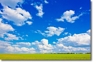
Weather Topic: What are Cumulus Clouds?
Home - Education - Cloud Types - Cumulus Clouds
 Next Topic: Drizzle
Cumulus clouds are fluffy and textured with rounded tops, and
may have flat bottoms. The border of a cumulus cloud
is clearly defined, and can have the appearance of cotton or cauliflower.
Cumulus clouds form at low altitudes (rarely above 2 km) but can grow very tall,
becoming cumulus congestus and possibly the even taller cumulonimbus clouds.
When cumulus clouds become taller, they have a greater chance of producing precipitation.
Next Topic: Drizzle
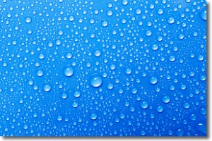
Weather Topic: What is Evaporation?
Home - Education - Precipitation - Evaporation
 Next Topic: Fog
Evaporation is the process which returns water from the earth
back to the atmosphere, and is another crucial process in the water cycle.
Evaporation is the transformation of liquid into gas, and it happens because
molecules are excited by the application of energy and turn into vapor.
In order for water to evaporate it has to be on the surface of a body of water.
Next Topic: Fog
Current conditions powered by WeatherAPI.com


