Weather Alerts for Alaska
1. Special Weather Statement for: Lower Yukon River; Lower Yukon and Innoko Valleys; North Slopes of the Western Alaska Range; Upper Kuskokwim Valley
2. Special Weather Statement for: Northern Seward Peninsula; Southern Seward Peninsula Coast; Interior Seward Peninsula
3. Special Weather Statement for: South Slopes Of The Central Brooks Range; Upper Koyukuk Valley; Central Interior
4. Special Weather Statement for: Upper Kobuk Valleys; Lower Koyukuk Valley
5. Special Weather Statement for: White Mountains and High Terrain South of the Yukon River; Upper Chena River Valley; Tanana Flats; Eielson AFB and Salcha; Goldstream Valley and Nenana Hills; Chatanika River Valley; Two Rivers; Fairbanks Metro Area; Nenana; Northern Denali Borough
6. Wind Advisory for: Eastern Alaska Range North of Trims Camp
7. Winter Storm Warning for: Kuskokwim Delta Coast and Nunivak Island
8. Winter Storm Warning for: Yukon Delta Coast
9. Winter Storm Watch for: Dalton Highway Summits
10. Winter Storm Watch for: Eastern Alaska Range South of Trims Camp
11. Winter Storm Watch for: Eastern Norton Sound and Nulato Hills
12. Winter Storm Watch for: Middle Yukon Valley
13. Winter Storm Watch for: St Lawrence Island
14. Winter Weather Advisory for: Eastern Alaska Range South of Trims Camp
15. Winter Weather Advisory for: Kuskokwim Valley West; Kuskokwim Valley East; Lime Village; Interior Kuskokwim Delta
Want more detail? Get the Complete 7 Day and Night Detailed Forecast!
Current U.S. National Radar--Current
The Current National Weather Radar is shown below with a UTC Time (subtract 5 hours from UTC to get Eastern Time).

National Weather Forecast--Current
The Current National Weather Forecast and National Weather Map are shown below.

National Weather Forecast for Tomorrow
Tomorrow National Weather Forecast and Tomorrow National Weather Map are show below.

North America Water Vapor (Moisture)
This map shows recent moisture content over North America. Bright and colored areas show high moisture (ie, clouds); brown indicates very little moisture present; black indicates no moisture.

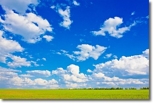
Weather Topic: What are Cumulus Clouds?
Home - Education - Cloud Types - Cumulus Clouds
 Next Topic: Drizzle
Cumulus clouds are fluffy and textured with rounded tops, and
may have flat bottoms. The border of a cumulus cloud
is clearly defined, and can have the appearance of cotton or cauliflower.
Cumulus clouds form at low altitudes (rarely above 2 km) but can grow very tall,
becoming cumulus congestus and possibly the even taller cumulonimbus clouds.
When cumulus clouds become taller, they have a greater chance of producing precipitation.
Next Topic: Drizzle
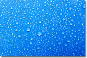
Weather Topic: What is Evaporation?
Home - Education - Precipitation - Evaporation
 Next Topic: Fog
Evaporation is the process which returns water from the earth
back to the atmosphere, and is another crucial process in the water cycle.
Evaporation is the transformation of liquid into gas, and it happens because
molecules are excited by the application of energy and turn into vapor.
In order for water to evaporate it has to be on the surface of a body of water.
Next Topic: Fog
Current conditions powered by WeatherAPI.com


